Water
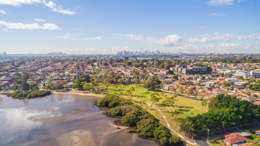
The City of Canada Bay has over 35km of foreshore along the Parramatta River and Iron Cove, which is why water management is important for our area. The majority of the rainwater and stormwater run-off in our catchment drains to these waterways via our roofs, roads, drainage network and open spaces. Due to our urbanised environment, we play a vital role in how the run-off water is managed to prevent our waterways becoming polluted.
Council actively looks at ways to address both biodiversity and water quality through catchment management initiatives such as the Catchment to Cove Project and by management of our pollution control devices or Gross Pollutant Traps.
The City of Canada Bay is a member of the Parramatta River Catchment Group (PRCG), which looks at the effects of urban run-off on the wider catchment. There is also information relating to the Beachwatch program run by the Department of Planning and Environment.
In 2014, the Our Living River initiative was launched by the PRCG to make the Parramatta River swimable again and to create a world class river that Sydney deserves.
Using total or integrated water cycle management and Water Sensitive Urban Design (WSUD) principles at the domestic level and broader catchment level, we can improve the quality of water that reaches our waterways. At a domestic level, rainwater tanks and grey water reuse systems reduce the amount of pollutants reaching our waterways by reducing the run-off created by roof areas.
The City of Canada Bay is largely surrounded by the waterways of the Parramatta River and Iron Cove. To preserve and improve the condition of these waterways, Council has installed numerous stormwater improvement devices and developed biodiversity projects to enhance the natural landscape.
The City of Canada Bay is an active member of the Parramatta River Catchment Group (PRCG). The PRCG is a regional organisation of local councils, state agencies and community representatives, which aim to work together to improve the health of the Parramatta River catchment.
The PRCG has prepared an Estuary Coastal Zone Management Plan (CZMP). The plan seeks to consider the estuary as a whole, identify priority issues, and set out a management strategy for implementation by the key stakeholders.
An CZMP is developed using a set of distinct steps and is a scientific approach to understanding the complex estuarine system and the actions needed to effectively manage human impacts upon this system. The eight-step process of developing the plan is defined and enforced by the NSW Government Estuary Management Program.
The Parramatta River Estuary Coastal Zone Management Plan was adopted by Council in 2013 and certified in accordance with Section 55G of the Coastal Protection Act. For more information please visit the Our Living River website or contact Council 9911 6555.
The City of Canada Bay is an urban landscape with lots of hard impermeable surfaces. These create undesirable conditions for natural landscapes, with increased run-off volume and larger amounts of pollutants being carried or transported to our waterways and foreshore areas.
We look after our catchments and waterways with initiatives such as the Catchment to Cove Project. The Catchment to Cove Project, completed in 2008, focused on improving waterway health and biodiversity in Sisters and Half Moon Bays in Iron Cove.
Biodiversity projects in our catchment are ongoing and to find out more refer to our biodiversity web pages. In total there are over 28 Pollution Control Devices (PCD) also know as Gross Pollutant Traps (GPTs), in the City of Canada Bay area.
These devices prevent at least 100 tonnes of pollutants (litter, leaves and sediment) from reaching our waterway and foreshore area. Litter, leaves and sediment are captured in basket within pits, which are emptied regularly. Collectively the pollution control devices help improve the health of our waterways and protect the vegetation and endangered species along our foreshore.
|
Gross Pollutant Trap, GPT Location |
Total Waste Removed (Tonnes*) |
||||
|
2018/2019 |
2019/2020 |
2020/2021 |
2021/2022 |
2022/2023 |
|
|
The Esplanade and Henricks Ave, Drummoyne |
3 |
1.4 |
0.8 |
1 |
0 |
|
Weddle St and Allison Park, Chiswick |
10.7 |
1.5 |
2.4 |
1.3 |
12 |
|
Barnstaple Rd, Five Dock |
8 |
3.2 |
5 |
3.5 |
11 |
|
Duchess Ave and Noble St, Five Dock |
3.1 |
2.1 |
2.8 |
1 |
2.5 |
|
Walton Cres, Abbotsford |
3 |
0 |
4.5 |
2.3 |
2.5 |
|
Henley Marine Dr and Brent St, Rodd Point |
1.8 |
0 |
0.5 |
2.3 |
3 |
|
Roseby St, Birkenhead Point |
1.9 |
1.7 |
1 |
1.3 |
0 |
|
Edwin St and College St, Drummoyne |
4 |
3.2 |
5.5 |
|
1 |
|
Drummoyne Oval, Drummoyne |
1.5 |
1.7 |
0.7 |
2.5 |
1 |
|
Barnwell Park Golf Course, Canada Bay |
0 |
1.5 |
1 |
|
0.5 |
|
Massey Park Golf Course, Concord |
0 |
76.8 |
80 (TBC – estimated value based on 2019/2020 data) |
0 |
0 |
|
Cabarita Park, Cabarita |
0 |
0 |
0 |
0 |
0 |
|
Brett Park, Drummoyne |
2 |
1.3 |
1.5 |
0 |
1 |
|
Henley St, Drummoyne |
0.6 |
0.7 |
1 |
2.5 |
0.8 |
|
Rhodes Park, Concord West |
1.3 |
0.9 |
1.5 |
3 |
1.2 |
|
Lovedale Place, Concord West |
1.4 |
0 |
1.8 |
0 |
0 |
|
Shoreline Drive, Rhodes |
1.6 |
1.2 |
1.4 |
0 |
1 |
|
Jean Wailes Ave, Rhodes |
0.8 |
0.6 |
1.5 |
0 |
0 |
|
Lewis Ave, Rhodes |
0.3 |
0.8 |
0 |
0 |
0 |
|
Henley Marine Drive Enviropods |
0.1 |
0 |
0 |
0 |
0 |
|
Annie Leggit Promenade, Rhodes |
1.2 |
0.6 |
1.2 |
0 |
1 |
|
Oulton Ave, Rhodes |
0.9 |
0.8 |
1.2 |
0 |
0.7 |
|
Nina Gray Ave West End, Rhodes |
0.4 |
0.8 |
0 |
0 |
0 |
|
Gauthorpe St West End, Rhodes |
0.4 |
1 |
1.5 |
0 |
0.7 |
|
Marquet St / Peake Ave, Rhodes |
0.4 |
0.8 |
0 |
0 |
0 |
|
Meredith Ave West End, Rhodes |
0.3 |
0.6 |
0 |
0 |
0 |
|
Darling Ave West End, Rhodes |
0 |
0.4 |
0 |
0 |
0 |
|
Point Park Rd, Rhodes |
0.6 |
2 |
1 |
0 |
0 |
|
Total |
49.3 |
105.6 |
118 |
20.7 |
39.9 |
* Table showing tonnes of pollutants removed from stormwater quality devices from the 2018-19 financial year to the 2022-23 financial year.
The Beachwatch Program was established in 1989 to monitor water quality across Sydney Beaches.
Beachwatch supports Councils to monitor and report on recreational water quality at swim sites in New South Wales. Water samples are collected and tested for bacteria to provide information on the level of sewage and stormwater pollution at beaches, and whether it is safe for swimming.
Water is also monitored at popular harbour swimming spots as part of the program. Water quality in the harbour has improved in recent years, however pollution from stormwater, sewer overflows and boats can cause pollution events.
Water quality reports can be found online at the Beachwatch webpage.
The City of Canada Bay is home to three popular harbour swimming locations: Cabarita Beach, Bayview Park Baths, and Chiswick Baths.
Water-sensitive urban design is the integration of urban planning and development with the management, protection and conservation of the water cycle as a whole.
The key principles of water-sensitive urban design, as stated in the Urban Stormwater – Best Practice Environmental Management Guidelines, are:
- Protect natural systems – protect and enhance natural water systems within urban developments.
- Integrate stormwater treatment into the landscape – use stormwater in the landscape by incorporating multiple use corridors that maximise the visual and recreational amenity of developments.
- Protect water quality – improve the quality of water draining from urban developments into the receiving environment.
- Reduce run-off and peak flows – reduce peak flows from urban development by local detention measures and minimise impervious areas.
- Add value while minimising development costs – minimise the drainage infrastructure cost of the development.
A range of applications are available for the integration of water-sensitive urban design concepts and technologies into urban developments. Types of techniques include (but are not limited to):
- Grassed or vegetated swales – primary treatment and conveyance function; can provide secondary treatment benefits.
- Filtration trenches – primary treatment and conveyance and detention options; can provide secondary treatment benefits.
- Bio-retention systems – secondary treatment, conveyance, detention and retention functions (through infiltration); can provide tertiary treatment benefits.
- Wetlands – tertiary treatment system, storage, detention, possible reuse options.
- Rainwater tanks – using stormwater as a resource – detention, retention, a substitute for drinking water in garden irrigation, car washing, toilet flushing, etc.
- Grey water reuse – collect from households, primary treatment on site, reuse for external irrigation or internal toilet flushing options.
- Rain gardens, rooftop greening, urban forests – provide natural vegetated features of aesthetic value and provide treatment function by filtering stormwater.
- Any combination of these and other techniques for the best possible outcome.
The City of Canada Bay supports the principles of water-sensitive urban design including the reuse of rainwater. Water sensitive urban design helps to reduce the negative impacts caused by development on the natural, built and human environments.
Council has adopted a Rainwater Reuse Policy which provides information on water sensitive urban design, rainwater reuse systems and maintenance.
In most cases the installation of a rainwater tank does not require Council approval such as with exempt development. Please refer to the Exempt and Complying Development section of Council's website.
For more information on building or renovating with sustainable development in mind, please visit the following websites:
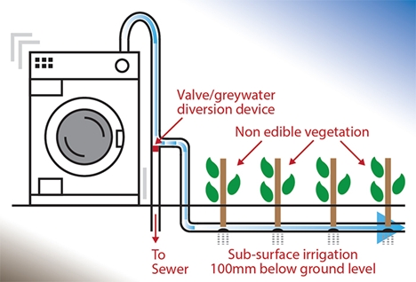
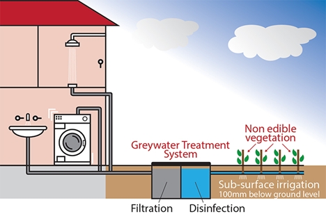
Domestic greywater is waste water from showers, baths, basins and laundries. Reusing greywater can help to reduce your drinking water bills, reduce the need for fertilisers for your lawn and gardens and also reduces the pressure on Sydney's water resources. It is possible to divert greywater to your gardens using a greywater diversion device or store greywater using a greywater treatment system. This page outlines the requirements for greywater diversion devices and greywater treatment systems.
Manual bucketing
Manual bucketing involves collecting small quantities of used water from washing machines and showers and disposing of it on your lawn and gardens. No approval from City of Canada Bay is required for manual bucketing.
Grey water diversion device
You do not need City of Canada Bay's approval to install a greywater diversion device providing that you meet the conditions in the NSW Guidelines for greywater reuse in sewered, single household residential premises.

Greywater treatment system
To install a greywater treatment system, you must have a Local Government Section 68 approval from City of Canada Bay. The requirements for a greywater treatment system are outlined in the NSW Guidelines for grey water reuse in sewered, single household residential premises.

More information
Contact Council’s Environmental Health Team by email health@canadabay.nsw.gov.au or phone 9911 6555.
Forms, fact sheets and guidelines

